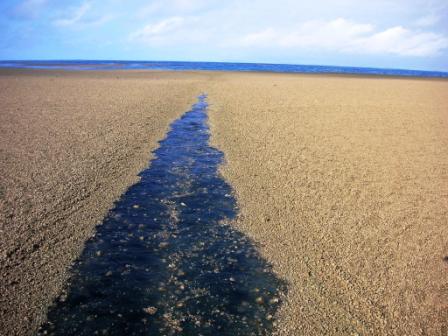
| I feel confident in stating that this is the rather rare case of an uncharted land mass. |
It rose, with a commotion I can only imagine in my nightmares, as a result of the impressive, if common, earthquake that hit the (relatively) sparsely populated Balochistan region earlier today.
This is not a particularly small hazard to navigation...that chunk of land is apparently a half-mile offshore. That ridge is estimated to be 20 to 40 feet high. I heard on the radio that it's essentially the seafloor itself that has experienced an upthrust as it is at the edge of a tectonic plate. Others are theorizing that it's the product of a mud volcano. It may therefore wash away in weeks or months.
I don't know the fate of the last "insta-island" I heard of, formed from an undersea volcano getting a little ahead of itself near the Pacific island of Tonga.
| Break out the asbestos Topsiders, Skipper.. |
| Queen Elizabeth II: Came a-cropper on an outcropping incorrectly charted. |
Not all of these "newfound lands", however, turn into an obliging drift of fine sand: the volcanic island of Surtsey appeared in the sense of "something rocky coming out of the boiling sea" in 1963 and kept appearing until 1967.
| The more things change, the more you run aground. |
Surtsey's now a small, somewhat eroded stump that nonetheless has begun to harbour plant and animal life, and is expected to endure for at least a hundred more years. A similar case is a small island in a warmer setting that is a byproduct of the famous Krakatoa volcanic explosion.
| "The child of Krakatoa": If you needed proof that life is tenacious, be a tree next to an active volcano. |
The Earth is very old, and the oceans change very slowly in their basic dimensions. And yet none of it is static. A chart, whether paper or electronic, is only a snapshot, and perhaps not even a snapshot of high resolution. As we've seen, some charts are not entirely accurate, and are to be considered less holy writ and more mild suggestion. And of course, it's not just nautical charts that are wrong: incorrect mapping in navigational apps, combined with a lack of common sense, can lead to situations both tragic and comic.
| Leaving through a jet plane... |
Cynicism and doubt are important parts of seamanship, and this is why we must continue to use eye and brain, positioned ideally on the deck and aimed forward, in addition to our magnificant displays in our glass cockpits, despite our GPS and our satellites and our supposed technological mastery that allows even the moronic to sail, and the delusional to cruise. Because it's not just a sudden appearance of an island, rare at that might seem, that could ruin your cruise.
 |
| Sailing through a pumice sea. Check yer filters! (c) Fredrik Fransson, S/V Maiken |
There's any number of things. Things that won't be on the chart.
| Now, imagine this looming out of the dark during your 3 AM, 28-knot, 15-foot waves, moonless 3 AM watch. Oh, and the radar's busted. Eat those carrots, crew! |
Who knows? You might witness an island being born.


No comments:
Post a Comment