 |
| Would it kill you to get a better boarding ladder? |
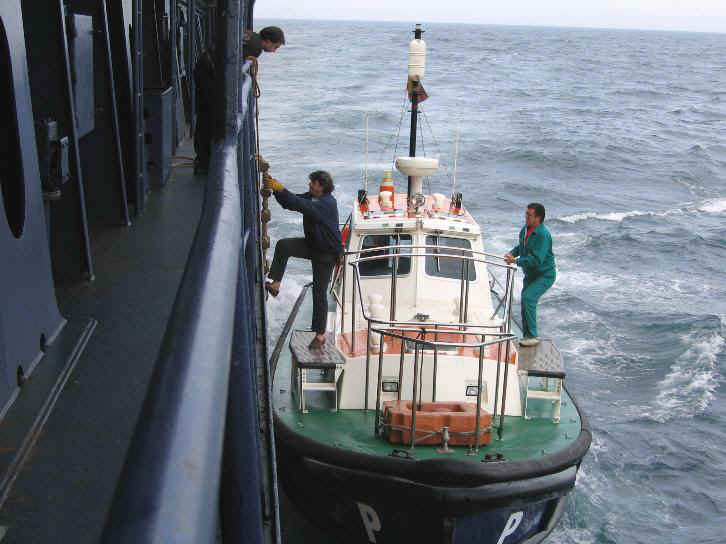
"Pilot" is a word with several nautical meetings. A maritime pilot, and by extension piloting or pilotage, is a professional mariner assigned (usually) by a governmental authority to board and guide merchant vessels and occasionally private yachts through tricky or congested harbours, passes or canals. Customarily, a pilot will advise the captain of the vessel, who remains in overall command (and takes overall responsibility for the safety of the vessel should he or she overrule the pilot's advice). Despite the impressive array of navigational sensors and displays available on modern merchant vessels (and quite a few private boats), many harbours and approaches remain dynamic and potentially dangerous environments, and "local knowledge" and even intuition are brought by the pilot to increase the chances of a successful, non-crunchy landing, mooring, through-passage or docking.
 |
| The left side of this graphic is white, and is not in any sense the flag of Poland. It's the "H" signal flag, and indicates to all nearby that a pilot is aboard the ship in question. That is not your cue to sail right in front of their bow. |
Pilots are not universal. They are required on the Panama Canal, for instance, where they actually supersede the captain in terms of guiding the ship, making that canal one of the few places in the world where the skipper legally must surrender control of the ship. By contrast, hired-by-the-hour "line handlers" suffice for private boats for Ontario's Welland Canal, which lifts both commercial (up to 750 feet in length) and recreational vessels (anything that won't fit on a boat trailer) between Lakes Erie and Ontario. But the fact is that while they are an essential service in many places too dangerous to approach for the unfamiliar, other places they are a mandatory method of scooping fees from every passing vessel. In still other places, pilots might be a good idea, but the absence of sufficient traffic capable of generating revenue, such in the reef-bound islands of the tropical Pacific, means "you're on your own, son!"
Of course, no human pilot is infalliable, and even the best of them can be crossed...literally in some cases (see above) by a reckless sailor with poor timing or impulse-control issues. So when the human pilot can't be present, sailors can resort to written "pilots", such as Sailing Directions for Area Insert Name Here. Locally, I use Sailing Directions for Lake Ontario, which comprises small photos, "chartlets", particularlities of the various ports, marinas, bridge heights and underwater dumps, along with descriptions of various land features, nav aids and the like.

Think of these types of pilots (in other contexts they are referred to as "pilots") as companion volumes to the paper charts used as the foundation of navigation.

The U.S. government has free Sailing Directions downloads of impressive volume (better not get the laptop wet) in both planning and "en route" forms, as well as offering regularly updated (and free as PDF downloads) Coast Pilots. Very comprehensive sailing directions, a.k.a. pilots, are also available from the expensive, if usually reliable United Kingdom Hydrological Office.
Another kind of pilot relates not to how you approach the land, but how you approach the weather. Getting the balance right means playing the laws of averages: you may decide to cross the Atlantic from Canada to Britain in early June rather than early July because you may get colder temperatutes, but also lighter winds, whereas July could bring early-season hurricane remnants chugging up the otherwise helpful Gulf Stream. Comprised of observations taken by personnel of the Royal and U.S. Navies from the late 1700s to the present, and averaged out for five by five degrees squares of ocean for each month of the year, "wind pilots", for lack of a better term, allow the sailor to improve her odds of picking a favourable time to make a passage through most of the waters of the world, and to sketch in a game plan in the south Pacific, for instance, that offers the least chance of either typhoons or dead calms, neither of which are desirable weather for most sailboats.

Admiralty Ocean Passages for the World, a venerable publication name-checked regularly in cruising narratives, is not cheap or lighter than an e-reader, but it offers in a pleasing and useful form a great mass of data of huge utility to the crew in planning mode. While the free U.S. pilot charts of the same type contain much of the same information, manipulating them in either PDF or in chart form is a little tiresome compared to a book. Nonetheless, the point is not the ease of use so much as the ease of understanding how historical weather trends can...or in certain years cannot...tilt the odds of having a steady passage with a minimum of nasty, wind-borne surprises.

This brings me to what might be considered the latest, Web-based version of the pilot chart: The Climatology of Global Ocean Winds (COGOW) project's website has collated ten or so years of data culled from satellites able to detect wind and wave movements across the oceans...from orbit. This is stunningly useful, as is quickly apparent when one trolls through the site in order to obtain "wind roses" for some tiny spot on the ocean, averaged not to the month but to a two-week span, and...here's the relevant bit...averaged over a nine-year span starting 12 years ago.
 |
| If you pick up on the nuances of this diagram, it could sway your decision to sail East South East. |
Is that a small sample? Yes, compared to the 200-year-plus range of observations of the U.S. and UK pilots. But it is arguably finer grained, in the sense that because the data was collected consistently by one machine functioning 24 hours a day for years on end, the data is not based on perhaps fuzzy methodology employed by subjective observers operating outside of proper instrumentation or indeed, prior to the adoption of Beaufort's scale, agreed-upon terms of reference. The "drill-down" brings us observations from areas a mere 0.5 x 0.5 degrees in size.

 |
| Close to where my friends on Silverheels III are, next week's forecast shows a continuing likelihood of northeasteries |
In sailing terms, that's miniscule. It's certainly a tiny fraction...I'll let you do the math...of the five by five degree areas covered by the "book" Pilots. And while the sample size over time is not great, a mere ten years or so, it does cover the period of "weird weather" of the last 15 years or so. Comparing these graphs to what the various "long-view" pilots show might be instructive, confusing and/or helpful, much like this blog. And yet I feel better for having found this intriguing addition to the passagemaker's store of knowledge.