| I'll be heading to the Compass Store. |
It's less "bear 282 degrees to reach the waypoint while I remove this blindfold" and more like "I don't often get lost, can retrace my steps and know that moss is usually on the north side of the tree...in this hemisphere". Like a significant subset of mostly, but by no means exclusively, boys, I've been fascinated by maps and geography since I was a little kid, and always had some sort of cheapo compass for turning suburban ravines into proto-Temples of Doom.
Of course, these days I fondle my Ritchie Globemaster in an unseemly fashion as much as any skipper and I like that Vion to the right, if not to the same intensity. Nice bit of gear, if pricey.
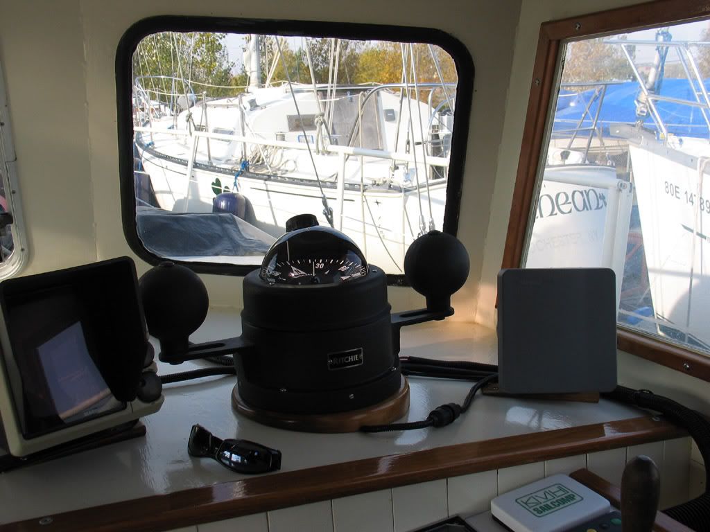 |
| Like AC/DC sang: "I've got the biggest balls of them all!" (Note: Balls are called "compensators", probably justly) |
 |
| Navigation problem or certain death? |
 |
| I have really tried to think of how this could be no one's fault, but I can't, like the ship, arrive there |
Unfortunately, while GPS, iThings, AIS, RADAR, plotters and contact lens 3DNet displays (oops, that last one is not here quite yet) provide information to the unintuitive navigator, but not necessarily context. Context, which includes looking out the window now and then, makes information/data points meaningful in a holistic sense, and seeing that big picture, even on a dark night short on photons, is critical to getting one's bearings.
People used to run aground on rocks. They frequently knew the rocks were there, they frequently knew, more-or-less, the chart co-ordinates of said sharp, point death minerals...but they couldn't do anything about it. The hawser snapped, the jib carried away, the boat wouldn't point, the current...argh! Cold, salty death in the form of gull breakfast, all charted very well indeed because lives depended upon staying away from the land almost all of the time. Keeping one's offing, or giving a wide berth to land, rocks and land with rocks, was considered prudent seamanship until quite recently. Sailing to a waypoint that wasn't a Nerf buoy? Utter folly.
Today, recreational sailors and even professionally crewed naval vessels can catastrophically run aground with comparative, even comical, ease. "The chart was wrong" is no real excuse, and yet old charts that do not feature last year's one-mile mole extension have been the basis for autopilot plots requiring extensive buffing out, at the very minimum, all the way up to Costa Concordia/USN Guardian levels of reef and habitat destruction and expense.
Are we ceding too much authority to our gadgets? Or is access to (assumed) accurate co-ordinates glossing over a lack of ability to interpret the information the gadget is supplying? Perhaps a corrolary might be "driver's lessons": When I was but a lad, driving lessons were for immigrants who'd never owned a car, people from places where cars were driven on the other side of the road, and people without dads or with dads with no gift for teaching. Mostly, dads taught you how to drive. In the intervening years, we've seen the professionalization of driving instruction, particularly aimed to first-time/young drivers. Partially, this may be a reaction to the increasing density of road traffic and the increasing density of data and external distractions. Another part may be that Dad isn't perhaps the Schmacher he fancies himself to be, and passing on his bad habits is not going to raise the collective skill set on the road. Irrespective of the reasons, the notably unsentimental insurance industry favours professionally trained new drivers with insurance discounts.
So there must be something to it.
Imagine something similar with boat operator courses, or navigation courses. The PCOC is an utter joke, unless your boating life consists of recognizing a fairway buoy and making a figure-8 in an inflatable (Oh, wait, that's the Toronto Harbour Licence, another useless cash grab).
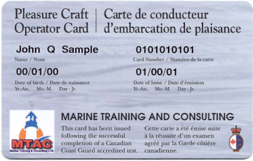 |
| A joke that's not particularly funny. |
So a modest proposal, for which I have no clue concerning implementation, might be that no GPS or plotter be sold in Canada without a basic navigation course, or perhaps that you need a REAL licence, and the course time to merit it, to drive a boat beyond a bathtub. You don't need a driver's licence to buy a car in Canada, just to drive it, so this wouldn't apply to some people retired from the helm, I suppose.
I realize my proposal goes against the libertarian impulse so prevalent in North America, an impulse with which I would have more sympathy if it wasn't dominated by Ayn Rand-loving selfish pricks. But I don't see licensing requirements for boat operation as an impingement on personal freedom, which of course implies the taking of personal responsibility to learn how to take one's bearings...and how to look out over the water to see if there's an obstacle your plotter doesn't know about.
That said, there are many old-school navigational tricks to try to up one's game of Buffing Reduction. On both our boats, I use a hand-held bearing compass (Davis, I think) from the cockpit. As I can reliably stand in the same spot (at the end of the tiller or at the outside helm on the steel boat), I can take "good enough" bearings (within 5 degrees) to shore features/day marks. I have to have the bearing compass about 65 inches off the steel boat's steely deck to overcome its inherent deviational effects, but the rest is the same. This sort of "eyeball navigation" is quick and dirty, and you can work out on a chart your distance offshore, your speed, your ETA and all sorts of interesting things. So can your GPS, but not with corroded batteries or at the bottom of the sea. In addition, I find that doing the mental and the visual work gives me a picture of "how things are". Staring at a plotter, while very useful in many ways, gives me a representation of how things are. A fine distinction, perhaps, but I enjoy the brainwork of sailing as much as the line-hauling, parrot maintenance and grog-swilling.
 |
| Talk about non-standard navigation. |
 |
| Yes, this is what I read for fun. |
There's very little neurology involved, but I hope some usefulness to sailors, in my fair-weather navigation trick of placing bits of coloured tape along the toe rail or lifelines/pipes at points 45 degrees, 60 degrees and 90 degrees to the helmsman's eye, relative to the centerline of the boat (and on both port and starboard sides). While on a straight compass course, preferably perpedicular to the shore, simply line up the shore feature at 45 degrees and note the time. At 90 degrees or "abaft", you note the time. Throw in the actual degree readings for comparisons and you can figure distance off.
 |
| As this is more fun to read on a nice day in the cockpit, get the waterproof cover version |
Five minutes of light math (which I well realize many people are no longer taught) and a paper chart (still made) later, you can determine your average speed and/or distance off. It's basic pilotage, but I find I can dispense with the bearing compass entirely and just use the watch and get pretty impressive accuracy "by eye" using this method of pre-chosen angles. Of course, you can take this sort of thing as far as you care to, but be warned, it can lead to hard-core sextant abuse.
Of course, you could use a GPS, could follow a depth contour or even flip a sextant on its side (far better than a bearing compass...), but where's the fun in that? (Note: there is in fact some fun in that.) Making basic navigation calls in the absence of electronics is part of seamanship, in my view, and if we had more of it, we'd have fewer avoidable accidents.


2 comments:
Back when I was a lad, I said something to the effect that "there should be 12 volts there" when troubleshooting some piece of gear. His reply has stuck with me some 35 years: "I know there should be but IS there?"
The chart plotter only gets you to "should", your eyes are the "is".
The plotter gives a representation of reality, just as the chart does. The radar/AIS give you what your eyes could see, if they could see (and range) dark coastlines on moonless nights, and at least some of the ships and boats that may be between you and that typically pointed and rocky demise.
There's a school of thought that says "no plotter at the helm". I haven't quite got there yet, but it's persuasive that the eye is drawn down when it should be drawn forward. My son is evidence of that with his game consoles.
So I concur completely. I'll trust a plotter to a greater degree when it's afraid to drown in a shipwreck.
Thanks for commenting.
Post a Comment