This is what happens, I guess, when artistic meets statistics.
I could watch it all day.
UPDATE: I've been in e-mail contact with Fernanda Viégas and Martin Wattenberg, the designers of this wind map, and while they are concerned (fairly naturally, I think) about the kind of bandwidth charges peering at this sort of graphical representation this could cost, they are considering making it more accessible (i.e. embeddable) for more general use.
So I'll stand by and await results. If nothing else, it's very beautiful. The developers in question have several very intriguing ways of presenting statistic in memorable, aesthetically pleasing fashions.
skip to main |
skip to sidebar


...a progressing work...
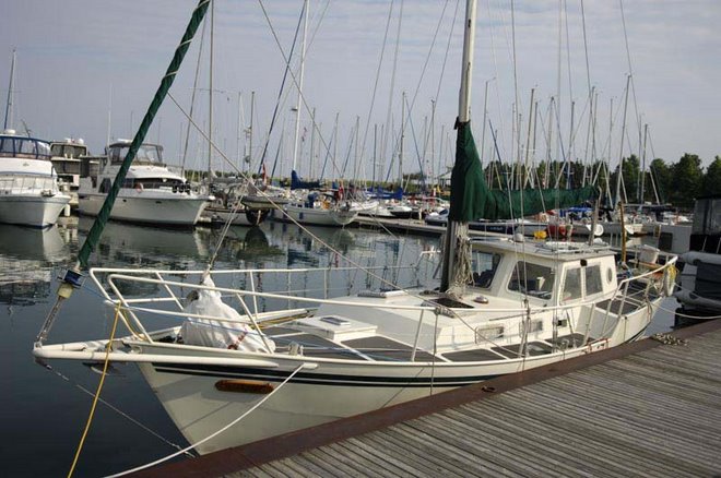
Because this is
just too much
boat
for Lake Ontario
Copyright (c) Marc Dacey/Dark Star Media 2006-2020. Above photo (c) Marc Dacey. Powered by Blogger.
The online log of S/V Alchemy, her restoration, her crew and their voyage
“You never enjoy the world aright till the sea itself floweth in your veins, till you are clothed with the heavens, and crowned with the stars: and perceive yourself to be the sole heir of the whole world.”-Thomas Traherne
"He that has patience may compass anything."-François Rabelais
"[The sea is] neither cruel nor kind ... Any apparent virtues it may have, and all its vices, are seen only in relation to the spirit of man who pits himself, in ships of his own building, against its insensate power."
-Denys Rayner
“For those who believe in God, most of the big questions are answered. But for those of us who can't readily accept the God formula, the big answers don't remain stone-written. We adjust to new conditions and discoveries. We are pliable. Love need not be a command nor faith a dictum. I am my own god. We are here to unlearn the teachings of the church, state, and our educational system. We are here to drink beer. We are here to kill war. We are here to laugh at the odds and live our lives so well that Death will tremble to take us.”
-Charles Bukowski
"A dream you dream alone is only a dream. A dream you dream together is reality." -Yoko Ono
My wife, my teenaged son and I plan to start voyaging in spring of 2020, plagues notwithstanding, for an estimated five to six years. I hope to move us aboard before that point to work out the kinks of living on a boat.
The careful reader will note the URL of this blog has "alchemy 2009" in it, a reference not only to our boat's name, but also to the original, anticipated departure date.
This is called "tempting the gods of the sea and life in general" and will not be modified. You have to know when to fight, and when to appease. Frankly, it matters that we go, not when we go. This is a good lesson for all aspiring voyagers, I think: the hubris of long-range planning lurks like an evil watermark on every "to-do" list.
Here you will find various notes on our preparations, labours and education as we try to become better sailors in a good old boat. I hope to continue to discuss in this blog the realities of preparing for a marine-focused extended sabbatical, the issues both mundane and philosophical confronting the potential cruiser, and the efforts required by everyone involved to make it happen.
Also, here is my current sailing resume.
Please note that all text and images on this site are copyrighted and may not be used without permission of their respective authors and creators.
Please note that I have not bothered to resize photos and they may be seen at full size and aspect ratio simply by clicking on them. Some photos formally hosted on third-party servers are not at present appearing; I will locally host these photos as I can afford the time to relink them.
Please also note that anonymous comments are usually spam and will typically be deleted without reading.
Author's text and most images other than product shots specifically created by product manufacturers are copyright 2006-2021 M. Dacey/Dark Star Productions. Photos sources linked from online news and related organizations are copyrighted to their creators.
"He that has patience may compass anything."-François Rabelais
"The Great Lakes sailor is wild-ocean nurtured; as much of an audacious mariner as any. "-Herman Melville
"[The sea is] neither cruel nor kind ... Any apparent virtues it may have, and all its vices, are seen only in relation to the spirit of man who pits himself, in ships of his own building, against its insensate power."
-Denys Rayner
“For those who believe in God, most of the big questions are answered. But for those of us who can't readily accept the God formula, the big answers don't remain stone-written. We adjust to new conditions and discoveries. We are pliable. Love need not be a command nor faith a dictum. I am my own god. We are here to unlearn the teachings of the church, state, and our educational system. We are here to drink beer. We are here to kill war. We are here to laugh at the odds and live our lives so well that Death will tremble to take us.”
-Charles Bukowski
"A dream you dream alone is only a dream. A dream you dream together is reality." -Yoko Ono
My wife, my teenaged son and I plan to start voyaging in spring of 2020, plagues notwithstanding, for an estimated five to six years. I hope to move us aboard before that point to work out the kinks of living on a boat.
The careful reader will note the URL of this blog has "alchemy 2009" in it, a reference not only to our boat's name, but also to the original, anticipated departure date.
This is called "tempting the gods of the sea and life in general" and will not be modified. You have to know when to fight, and when to appease. Frankly, it matters that we go, not when we go. This is a good lesson for all aspiring voyagers, I think: the hubris of long-range planning lurks like an evil watermark on every "to-do" list.
Here you will find various notes on our preparations, labours and education as we try to become better sailors in a good old boat. I hope to continue to discuss in this blog the realities of preparing for a marine-focused extended sabbatical, the issues both mundane and philosophical confronting the potential cruiser, and the efforts required by everyone involved to make it happen.
Also, here is my current sailing resume.
Please note that all text and images on this site are copyrighted and may not be used without permission of their respective authors and creators.
Please note that I have not bothered to resize photos and they may be seen at full size and aspect ratio simply by clicking on them. Some photos formally hosted on third-party servers are not at present appearing; I will locally host these photos as I can afford the time to relink them.
Please also note that anonymous comments are usually spam and will typically be deleted without reading.
Author's text and most images other than product shots specifically created by product manufacturers are copyright 2006-2021 M. Dacey/Dark Star Productions. Photos sources linked from online news and related organizations are copyrighted to their creators.
I've been told I should label this stuff
- AIS (14)
- Alleged improvement (1)
- Alleged improvements (137)
- Anchor and tackle (22)
- Autopilot (6)
- Batteries (22)
- Berths (4)
- Boat club (23)
- Boat show (5)
- Celestial (6)
- Chandleries (8)
- chartering (1)
- Clearing in/out (3)
- Commissioning (32)
- Comms (7)
- Costs and cruising (48)
- Damage remediation (6)
- Decommissioning (7)
- Deliveries/crewing for others (1)
- Docks and moorings (5)
- Drogue (1)
- Drones (1)
- Education and training (18)
- Electrons (63)
- Engine things (45)
- EPIRB (3)
- Fabrications (36)
- Family matters (3)
- financials (8)
- Forepeak (3)
- Fuel system (3)
- Galley and provisions (8)
- Gear and products (77)
- Gratitude (4)
- Hardware (13)
- historical (4)
- Hull and structure (32)
- Hydraulics and helm (5)
- Illuminations (3)
- Instruments (4)
- Insurance (1)
- Launch/haulout (21)
- Liferaft (1)
- Low-buck (10)
- Maintenance (68)
- Mooring/docking (11)
- Nautical terms (3)
- Naval affairs (1)
- Navigation (28)
- News (3)
- Oceanic (19)
- Off-topic ramblings (58)
- Painting (6)
- Paints and coatings (6)
- Pilothouse (21)
- Piracy (1)
- Plunbing/tankage (11)
- Politics (3)
- Prep/cleaning (15)
- Props and drivetrains (1)
- Racing (2)
- RADAR (5)
- Rant (5)
- Renewable energy (1)
- Renewables (1)
- Rescue (8)
- Research/commentary (9)
- rigging (1)
- Rigs and decks and gear (34)
- Risk assessment (12)
- Sails (18)
- Salvage (4)
- Sea peoples (5)
- Sea traffic (2)
- Seamanship (48)
- Security matters (6)
- ship yard (1)
- Solar and wind power (3)
- SSB radio (3)
- Stowage and spares (19)
- Surveys (3)
- Tactics (1)
- Tenders and outboards (8)
- Testing (3)
- Tools and tricks (52)
- Valiente (47)
- VHF radio (7)
- Watermaker (1)
- Weatherly (27)
- winterization (1)
- Wiring (17)
Inexplicably Compelling Posts
-
 "Arr, matey, I be parallel parking this scurvy scow!" Clearly, despite the eclipsing in most senses of the Age of Sail, the al...
 -
 Leaving from Port Credit, all looked fabulous forward... ...but in order to get a hint of what was to come, you had to look aft. A...
 -
The little float coat is sort of cute, until one contemplates its intended use. My wife recently returned from a delivery (see previou...
-
 Skipper Bruce Clark obtains the latest GRIB files. These and guidance from Southbound II would keep us (mostly) on the right side of tro...
 -
Now available on eBay for about ten bucks. Last year, my father-in-law gave his 11-year-old grandson a venerable IBM Thinkpad 600X. H...


Ravings to date
-
►
2020
(20)
- ► 12/27 - 01/03 (1)
- ► 10/04 - 10/11 (1)
- ► 05/31 - 06/07 (2)
- ► 04/19 - 04/26 (2)
- ► 04/12 - 04/19 (2)
- ► 03/29 - 04/05 (2)
- ► 03/22 - 03/29 (1)
- ► 03/01 - 03/08 (1)
- ► 02/23 - 03/01 (1)
- ► 02/16 - 02/23 (3)
- ► 01/26 - 02/02 (1)
- ► 01/12 - 01/19 (2)
- ► 01/05 - 01/12 (1)
-
►
2019
(10)
- ► 08/25 - 09/01 (1)
- ► 07/14 - 07/21 (1)
- ► 05/26 - 06/02 (1)
- ► 05/12 - 05/19 (3)
- ► 04/07 - 04/14 (2)
- ► 02/03 - 02/10 (1)
- ► 01/27 - 02/03 (1)
-
►
2018
(22)
- ► 12/30 - 01/06 (1)
- ► 11/25 - 12/02 (1)
- ► 10/14 - 10/21 (2)
- ► 09/16 - 09/23 (1)
- ► 09/02 - 09/09 (1)
- ► 05/20 - 05/27 (1)
- ► 05/13 - 05/20 (1)
- ► 04/29 - 05/06 (3)
- ► 04/15 - 04/22 (2)
- ► 04/08 - 04/15 (1)
- ► 04/01 - 04/08 (1)
- ► 03/18 - 03/25 (1)
- ► 03/11 - 03/18 (2)
- ► 02/18 - 02/25 (2)
- ► 02/11 - 02/18 (1)
- ► 01/21 - 01/28 (1)
-
►
2017
(24)
- ► 12/24 - 12/31 (1)
- ► 11/05 - 11/12 (1)
- ► 09/17 - 09/24 (1)
- ► 09/10 - 09/17 (1)
- ► 08/13 - 08/20 (1)
- ► 07/23 - 07/30 (2)
- ► 07/16 - 07/23 (2)
- ► 07/02 - 07/09 (1)
- ► 06/25 - 07/02 (1)
- ► 06/18 - 06/25 (1)
- ► 05/28 - 06/04 (1)
- ► 05/21 - 05/28 (1)
- ► 05/14 - 05/21 (1)
- ► 05/07 - 05/14 (1)
- ► 04/09 - 04/16 (2)
- ► 03/19 - 03/26 (1)
- ► 03/05 - 03/12 (1)
- ► 02/05 - 02/12 (1)
- ► 01/29 - 02/05 (1)
- ► 01/22 - 01/29 (1)
- ► 01/15 - 01/22 (1)
-
►
2016
(31)
- ► 12/18 - 12/25 (1)
- ► 12/04 - 12/11 (1)
- ► 11/27 - 12/04 (2)
- ► 10/23 - 10/30 (1)
- ► 10/09 - 10/16 (1)
- ► 09/25 - 10/02 (1)
- ► 09/11 - 09/18 (1)
- ► 09/04 - 09/11 (1)
- ► 08/21 - 08/28 (1)
- ► 07/31 - 08/07 (2)
- ► 07/24 - 07/31 (2)
- ► 07/10 - 07/17 (1)
- ► 06/12 - 06/19 (1)
- ► 05/29 - 06/05 (2)
- ► 05/15 - 05/22 (1)
- ► 05/08 - 05/15 (1)
- ► 05/01 - 05/08 (2)
- ► 04/17 - 04/24 (2)
- ► 04/10 - 04/17 (1)
- ► 04/03 - 04/10 (1)
- ► 03/27 - 04/03 (1)
- ► 02/07 - 02/14 (1)
- ► 01/24 - 01/31 (1)
- ► 01/17 - 01/24 (1)
- ► 01/03 - 01/10 (1)
-
►
2015
(30)
- ► 12/27 - 01/03 (1)
- ► 11/22 - 11/29 (1)
- ► 11/01 - 11/08 (1)
- ► 10/18 - 10/25 (1)
- ► 10/11 - 10/18 (1)
- ► 09/27 - 10/04 (1)
- ► 09/20 - 09/27 (1)
- ► 09/13 - 09/20 (1)
- ► 09/06 - 09/13 (1)
- ► 08/23 - 08/30 (1)
- ► 08/16 - 08/23 (1)
- ► 08/09 - 08/16 (1)
- ► 07/26 - 08/02 (1)
- ► 05/17 - 05/24 (1)
- ► 05/10 - 05/17 (1)
- ► 05/03 - 05/10 (2)
- ► 04/26 - 05/03 (2)
- ► 04/19 - 04/26 (1)
- ► 04/12 - 04/19 (1)
- ► 03/29 - 04/05 (1)
- ► 03/15 - 03/22 (1)
- ► 03/01 - 03/08 (1)
- ► 02/15 - 02/22 (2)
- ► 01/25 - 02/01 (1)
- ► 01/18 - 01/25 (1)
- ► 01/11 - 01/18 (1)
- ► 01/04 - 01/11 (1)
-
►
2014
(46)
- ► 12/07 - 12/14 (1)
- ► 11/16 - 11/23 (1)
- ► 11/09 - 11/16 (1)
- ► 11/02 - 11/09 (2)
- ► 10/26 - 11/02 (2)
- ► 10/19 - 10/26 (1)
- ► 10/05 - 10/12 (1)
- ► 09/28 - 10/05 (1)
- ► 09/21 - 09/28 (2)
- ► 09/14 - 09/21 (1)
- ► 08/31 - 09/07 (1)
- ► 08/24 - 08/31 (2)
- ► 08/10 - 08/17 (1)
- ► 08/03 - 08/10 (1)
- ► 07/27 - 08/03 (2)
- ► 07/20 - 07/27 (2)
- ► 07/13 - 07/20 (3)
- ► 06/01 - 06/08 (1)
- ► 05/25 - 06/01 (1)
- ► 05/18 - 05/25 (1)
- ► 05/11 - 05/18 (1)
- ► 05/04 - 05/11 (1)
- ► 04/27 - 05/04 (1)
- ► 04/20 - 04/27 (4)
- ► 04/13 - 04/20 (1)
- ► 04/06 - 04/13 (1)
- ► 03/30 - 04/06 (1)
- ► 03/09 - 03/16 (1)
- ► 03/02 - 03/09 (1)
- ► 02/23 - 03/02 (3)
- ► 02/09 - 02/16 (1)
- ► 01/19 - 01/26 (2)
-
►
2013
(71)
- ► 12/22 - 12/29 (2)
- ► 12/15 - 12/22 (1)
- ► 12/08 - 12/15 (2)
- ► 11/24 - 12/01 (2)
- ► 11/03 - 11/10 (1)
- ► 10/27 - 11/03 (1)
- ► 10/20 - 10/27 (1)
- ► 10/06 - 10/13 (1)
- ► 09/22 - 09/29 (2)
- ► 09/15 - 09/22 (2)
- ► 09/08 - 09/15 (1)
- ► 09/01 - 09/08 (2)
- ► 08/25 - 09/01 (2)
- ► 08/11 - 08/18 (2)
- ► 08/04 - 08/11 (1)
- ► 07/28 - 08/04 (2)
- ► 07/07 - 07/14 (1)
- ► 06/23 - 06/30 (1)
- ► 06/16 - 06/23 (1)
- ► 06/09 - 06/16 (1)
- ► 06/02 - 06/09 (1)
- ► 05/26 - 06/02 (1)
- ► 05/19 - 05/26 (1)
- ► 05/12 - 05/19 (2)
- ► 05/05 - 05/12 (1)
- ► 04/28 - 05/05 (3)
- ► 04/21 - 04/28 (2)
- ► 04/14 - 04/21 (3)
- ► 04/07 - 04/14 (2)
- ► 03/31 - 04/07 (2)
- ► 03/24 - 03/31 (3)
- ► 03/17 - 03/24 (2)
- ► 03/10 - 03/17 (4)
- ► 03/03 - 03/10 (2)
- ► 02/24 - 03/03 (1)
- ► 02/17 - 02/24 (3)
- ► 02/10 - 02/17 (3)
- ► 02/03 - 02/10 (3)
- ► 01/13 - 01/20 (3)
-
▼
2012
(31)
- ► 12/16 - 12/23 (1)
- ► 12/09 - 12/16 (1)
- ► 11/18 - 11/25 (1)
- ► 11/04 - 11/11 (1)
- ► 10/28 - 11/04 (1)
- ► 10/21 - 10/28 (1)
- ► 09/02 - 09/09 (1)
- ► 07/22 - 07/29 (1)
- ► 06/03 - 06/10 (2)
- ► 05/20 - 05/27 (1)
- ► 04/22 - 04/29 (1)
- ► 04/08 - 04/15 (1)
- ► 03/18 - 03/25 (2)
- ► 03/11 - 03/18 (2)
- ► 02/19 - 02/26 (2)
- ► 02/12 - 02/19 (1)
- ► 02/05 - 02/12 (2)
- ► 01/29 - 02/05 (3)
- ► 01/22 - 01/29 (2)
- ► 01/15 - 01/22 (1)
- ► 01/01 - 01/08 (1)
-
►
2011
(30)
- ► 12/04 - 12/11 (2)
- ► 11/06 - 11/13 (2)
- ► 10/30 - 11/06 (1)
- ► 10/23 - 10/30 (3)
- ► 10/16 - 10/23 (1)
- ► 09/04 - 09/11 (1)
- ► 08/14 - 08/21 (1)
- ► 08/07 - 08/14 (2)
- ► 07/31 - 08/07 (1)
- ► 07/24 - 07/31 (1)
- ► 06/12 - 06/19 (1)
- ► 06/05 - 06/12 (3)
- ► 05/29 - 06/05 (1)
- ► 05/01 - 05/08 (2)
- ► 04/03 - 04/10 (1)
- ► 03/13 - 03/20 (1)
- ► 02/27 - 03/06 (2)
- ► 02/13 - 02/20 (1)
- ► 02/06 - 02/13 (1)
- ► 01/09 - 01/16 (1)
- ► 01/02 - 01/09 (1)
-
►
2010
(22)
- ► 12/26 - 01/02 (2)
- ► 12/12 - 12/19 (1)
- ► 11/14 - 11/21 (1)
- ► 11/07 - 11/14 (1)
- ► 09/26 - 10/03 (1)
- ► 09/12 - 09/19 (1)
- ► 08/29 - 09/05 (1)
- ► 08/08 - 08/15 (1)
- ► 08/01 - 08/08 (2)
- ► 07/18 - 07/25 (1)
- ► 06/13 - 06/20 (1)
- ► 05/30 - 06/06 (1)
- ► 05/09 - 05/16 (1)
- ► 04/25 - 05/02 (2)
- ► 04/18 - 04/25 (2)
- ► 03/28 - 04/04 (1)
- ► 01/17 - 01/24 (1)
- ► 01/03 - 01/10 (1)
-
►
2009
(27)
- ► 12/27 - 01/03 (1)
- ► 11/22 - 11/29 (2)
- ► 09/27 - 10/04 (1)
- ► 09/13 - 09/20 (1)
- ► 09/06 - 09/13 (1)
- ► 08/23 - 08/30 (2)
- ► 08/16 - 08/23 (1)
- ► 08/09 - 08/16 (3)
- ► 08/02 - 08/09 (1)
- ► 07/12 - 07/19 (1)
- ► 07/05 - 07/12 (1)
- ► 06/21 - 06/28 (2)
- ► 05/24 - 05/31 (1)
- ► 05/03 - 05/10 (1)
- ► 04/05 - 04/12 (1)
- ► 03/22 - 03/29 (2)
- ► 03/15 - 03/22 (1)
- ► 03/08 - 03/15 (1)
- ► 02/08 - 02/15 (2)
- ► 01/25 - 02/01 (1)
-
►
2008
(18)
- ► 12/28 - 01/04 (1)
- ► 11/02 - 11/09 (1)
- ► 10/26 - 11/02 (1)
- ► 10/12 - 10/19 (1)
- ► 09/21 - 09/28 (2)
- ► 09/14 - 09/21 (1)
- ► 08/24 - 08/31 (1)
- ► 06/29 - 07/06 (2)
- ► 06/15 - 06/22 (1)
- ► 05/18 - 05/25 (2)
- ► 05/11 - 05/18 (4)
- ► 01/13 - 01/20 (1)
-
►
2007
(20)
- ► 12/09 - 12/16 (1)
- ► 10/21 - 10/28 (1)
- ► 09/16 - 09/23 (2)
- ► 08/12 - 08/19 (3)
- ► 07/01 - 07/08 (1)
- ► 06/17 - 06/24 (1)
- ► 05/13 - 05/20 (3)
- ► 05/06 - 05/13 (1)
- ► 04/22 - 04/29 (2)
- ► 04/08 - 04/15 (2)
- ► 03/25 - 04/01 (1)
- ► 03/18 - 03/25 (2)
Possibly fictional bio
- Rhys
- Middle-aged, bookish Canadian with compact family in process of exploding career and prospects in favour of lengthy, low-rent sabbatical has boat, seeks ocean. Must have non-smoking bilges. All contents (C) 2007-2021 M. Dacey/Dark Star Productions
Helpful, Strange or Irrelevant
- 59 North: A Swan 48 you can charter!
- A Prosperous Way Down: Thoughts on the simpler life
- AnchorRight: Home of the SARCA anchor line
- Annie Hill's Voyaging Notes: Veteran sailor on a budget
- Anything Sailing: The forum with 30% fewer armchair admirals
- Atlas Obscura: A rough guide to the weird
- Attainable Adventure Cruising: The Offshore Voyaging Reference Site
- Benners Adrift
- Beth and Evans: Very experienced cruisers and excellent writers
- BigOceansBlog: A Contessa 26's odyssey
- BoatBits: Tidbits, but with salt.
- Boatman Phil's Yacht Deliveries: When you're too busy to sail your own damn boat.
- Bob Perry's Yacht Design According to Perry
- Bogart Engineering, makers of the Pentametric
- Bogat Engineering's Pentametric battery systems monitor
- Buffalo Nickel, an FPB 64 motor yacht
- Building a Westsail 42
- Building Brupeg: Kiwis in Australia rebuild a fishing trawler for high-latitude voyaging
- Building Odyssey, a Dix 43 in aluminum
- Canadian cruising couple on a cat in the Caribbean
- Climatology of Global Ocean Winds: The Online Wind Pilot
- Cox Engineering: A metallurgist shares great info for yachties
- Cruisers and Sailing Forums
- Cruising Guide to Nova Scotia
- Cruising: What Works
- CSSN: Where be pirates?
- Current Space Weather
- David Burch Nav/Weather Blog
- Deckskills: Professional mariner training useful to amateurs
- Delfin: A Steel Trawler, an Interesting Read
- DEnali Rose: a Nauticat 43 on passage
- Distant Shores: Paul and Sheryl Shard's long-running cruising TV show
- Dock Six Chronicles: The View from Port Dover
- Dreamtime Sail: A Whitby 42 ketch in Australia
- Earth Wind Map: Very nice worldwide baro and wind viewer
- Excellent Animated Knots
- Far Reaches: The tools and techniques of a skilled restorer
- Fishing Under Sail: Because you might as well
- Fortress Anchors: No, They Aren't Danforths
- Fractions of an Inch to Millimetre Table
- Frank Singleton's Weather Page
- Frank Singleton's Weather: A meterologist and sailor with the lowdown on marine weather
- gCaptain: Professional mariners' news site with interest to all sailors
- Giulietta Racing: A custom Delmar Conte 1200 competes in ORC
- Global Emergency Map: For when you need a Route B
- Harry Bryan: Boat builder
- Holland Marine Products: My chandlery of choice
- How to build a WiFi Repeater for your boat
- Hydro International: All about hydrography
- In Your Footsteps: Havens and how to find them
- Integrated Power Systems
- Janet Groene's BoatCook: Eat well, afloat
- John Vigor's Blog
- Kathy Parsons' Spanish and French for Cruisers
- Kettlewell Cruising: A veteran cruising writer who knows his business
- Kim Chow Around the World
- Lia Ditton: Sailor-Artist-Adventurer
- Life at 20°: Voyaging on a Malo 42
- Lloyd's List: Has something sunk in my general direction?
- M.B. Marsh Marine Design: Doing it right the first time
- Marine Diesel Basics: Dennison Berwick's sage advice
- Marine How To: An excellent compendium of boat tips
- Marine LEDS Canada: Well-priced, well made LED lighting
- McMaster-Carr: Thingies and doodads a speciality
- Metalcraft Marine: Fireboats and more
- Michael Kasten, Yacht Designer: Nice boats, and superb writing about design
- Mylène Paquette Rowed Across the Atlantic
- National Yacht Club
- Nautical Almanac PDFs, plus supplemental tables
- Nautical Mind Booksellers
- Navagear: Marine Electronics and Reviews
- Navigation Mac: Francis Fustier's interesting blog
- New Found Metals: Portlights of value
- Nieuwe Zorg: touring a century-old Dutch skûtsje
- Noonsite: News and views cruisers can use
- Ocean Weather Services: Get routed
- Oceanbrake: Makers of Jordan Series Drogues
- On Ainia: A Bristol 45.5 around the world
- Ontario Boat Builders' Co-op: Socialism at its wettest
- Outback Charge Controllers
- Panbo: Marine Electronics
- Peter Karadi: Custom Yacht Builder, Fabricator and Restorer
- Piracy Reporting Centre
- PKYS Inc.: Simple explanations of complex boat electrical topics
- Port Credit Marine Surveys: Wallace knows more than you about boats
- Proper Course
- S/V Atalanta: Refitting a Little Harbor 44
- S/V Beach House, an Endeavour 42 at large in the Caribbean
- S/V Belafonte: A two-year circ in a Malo 42
- S/V Bluebottle, a Pacific-crossing Lidgard 49 foot steel ketch
- S/V Byamee: a steel cutter now on passage
- S/V Chasing Summer: Rebuilding a Spencer 42
- S/V Cygnus 3: An Oyster 45 on passage
- S/V Easy Go, a homebuilt, junk-rigged dory schooner
- S/V Eolian, a Downeast 45 ketch
- S/V Fiona: Eric Forsythe's sailed more than you ever will
- S/V Fortuitous, a Catalina 22 in Barnegat Bay, NJ
- S/V Galactic, a 45 foot steel cutter
- S/V Giulietta, a custom-built Portuguese ORC racer
- S/V Goodonya, an Ericson 39B cruising Australia and beyond
- S/V Hawk: Beth Leonard and Evans Starzinger
- S/V Hermes: Wandering in a Pearson 33
- S/V Heron, a Beneteau 47 on cruise
- S/V Isbjörn: Crew on a classic Swan 48
- S/V Jakatar, a very philosophical Corbin 39 in Portugal
- S/V Joana, a Steel Roberts 53
- S/V MingMing: Simply solo sailing in a junk-rig
- S/V Mollymawk: A steel ketch at the ends of the Earth
- S/V Momentum: "The Motorsailer Project"
- S/V Nereida: Voyaging with the world's oldest female solo circumnavigator
- S/V Nine of Cups: Newer circ blog
- S/V Nine of Cups: Older circ blog
- S/V Obsession, a Beneteau 305 out of P.E.I.
- S/V Ocelot, a world-girding Kronos 48 catamaran
- S/V Panache: A Leopard 48 cat goes both hither and yon
- S/V Panache: A Leopard 48 cat on a circ
- S/V Panope: Refitting a Colvin 34
- S/V Papillon: An O'Day 25 in Minnesota
- S/V Pelican: Following a Dream
- S/V Pétillant, a voyaging Jeanneau Sun Odyssey 43DS
- S/V Precipice
- S/V Quiescence: A Catalina 42 on passage for the tropics
- S/V Rhapsody, refitting a neglected Aries 32
- S/V Seal: An expedition yacht in high-latitude charter
- S/V Sentinel: A steel Roberts 38 that spent seven years voyaging
- S/V Silas Crosby, a 36 foot Brent Swain cutter in steel
- S/V Skye: A Lyle Hess 32...built in 1988
- S/V Solstice: a Cape George 31 cutter in charter
- S/V Speedwell: Keeping cruising simple may involve junk
- S/V Teleport: a junk-rigged North Atlantic 29
- S/V Time Machine
- S/V Totem: Good ideas from the crew of a Stevens 47
- S/V Tres Hombres, a working sail freighter out of Grenada
- S/V Valhalla: A Fuji 32 ketch with a prolific writer at the helm
- S/V Veleda IV: World Cruising an Ontario 32
- S/V WhiteBird: How bad could it get?
- S/V Windway, a steel Joshua 40 preparing for a circ
- Sabre Dancing: Rebuilding a steel Roberts 38
- Safe Propane Installations: how to avoid being a horrible warning
- Sail Far, Live Free: Maritime musings from Lake Michigan
- Sailing School Brittany: A great place for RYA-grade sail training
- Sailing Simplicity: A skipper ponders the simple life aboard
- Sailing Totem, a blog about a family doing a circ on a Stevens 47
- Sea level barometric pressure conversion tool
- SetSail: Thoughts on all aspects of cruising with ocean vets The Dashews
- Shipping and Freight Resource: A blog that's laden with information on cargo transport
- Small Boat Projects: Don't be a horrible warning
- Southbound II: Herb Hilgenberg, Weather Forecaster and Router
- Tad Roberts, B.C.-based designer of some salty boats
- Teach yourself electrics!
- Tenaya Travels: 50,000 Miles in a HR 40
- The Boat Galley: Practical tips for cooking aboard
- The Engineering Toolbox: All sorts of helpful calculations
- The Greenheart Project: Developing "Sustainable" Shipping
- The Incredible Hull
- The Marine Installer's Rant
- The Natural Navigator: Accessing one's inner chartplotter
- The NN10 Nesting Dinghy
- The Nordkyn Project: Design and build of an ocean-going, 13 m sloop
- The old "SailCalc" site, temporarily hosted
- The Voyages of s/v Sequitur on a Leisurely Circ
- The Voyages of Silverheels III
- TidesChart: What goes up...
- Trackline Attachment Syndrome
- Untie the Lines: Video diary of a young German rehabbing a beat-up alu sailboat
- Vixen's Voyage: Around the world in a wooden 34-footer
- VolksCruiser: Why pay retail?
- Volumes of Salt: My sea-related book reviews
- Voyager Windvanes
- Wallace Gouk, Marine Surveyor
- Warpaint: How the Royal Navy keeps the steel unrusted
- Water levels at Toronto
- Wind Map...very cool
- WindGURU
- World Tide Finder
- Yacht Piracy
- Yachtsurvey: David Pascoe on all he surveys
The Whole of the Moon
CURRENT MOON
World Climate Widget
A world of readers
Labels
- Alleged improvements (137)
- Gear and products (77)
- Maintenance (68)
- Electrons (63)
- Off-topic ramblings (58)
- Tools and tricks (52)
- Costs and cruising (48)
- Seamanship (48)
- Valiente (47)
- Engine things (45)
- Fabrications (36)
- Rigs and decks and gear (34)
- Commissioning (32)
- Hull and structure (32)
- Navigation (28)
- Weatherly (27)
- Boat club (23)
- Anchor and tackle (22)
- Batteries (22)
- Launch/haulout (21)
- Pilothouse (21)
- Oceanic (19)
- Stowage and spares (19)
- Education and training (18)
- Sails (18)
- Wiring (17)
- Prep/cleaning (15)
- AIS (14)
- Hardware (13)
- Risk assessment (12)
- Mooring/docking (11)
- Plunbing/tankage (11)
- Low-buck (10)
- Research/commentary (9)
- Chandleries (8)
- Galley and provisions (8)
- Rescue (8)
- Tenders and outboards (8)
- financials (8)
- Comms (7)
- Decommissioning (7)
- VHF radio (7)
- Autopilot (6)
- Celestial (6)
- Damage remediation (6)
- Painting (6)
- Paints and coatings (6)
- Security matters (6)
- Boat show (5)
- Docks and moorings (5)
- Hydraulics and helm (5)
- RADAR (5)
- Rant (5)
- Sea peoples (5)
- Berths (4)
- Gratitude (4)
- Instruments (4)
- Salvage (4)
- historical (4)
- Clearing in/out (3)
- EPIRB (3)
- Family matters (3)
- Forepeak (3)
- Fuel system (3)
- Illuminations (3)
- Nautical terms (3)
- News (3)
- Politics (3)
- SSB radio (3)
- Solar and wind power (3)
- Surveys (3)
- Testing (3)
- Racing (2)
- Sea traffic (2)
- Alleged improvement (1)
- Deliveries/crewing for others (1)
- Drogue (1)
- Drones (1)
- Insurance (1)
- Liferaft (1)
- Naval affairs (1)
- Piracy (1)
- Props and drivetrains (1)
- Renewable energy (1)
- Renewables (1)
- Tactics (1)
- Watermaker (1)
- chartering (1)
- rigging (1)
- ship yard (1)
- winterization (1)
You like me, you really like me
People with a high tolerance for boredom
S/V Alchemy, 2007, Toronto
...a progressing work...
3 comments:
As Canadians watching Buffalo NY television for nearly 69 years we've become accustomed to seeing the US weather stop at the Great Lakes and the 49th parallel. Where do they suppose all that Artic air comes from in the winter? ;-)
I assume they assume Russia or perhaps Alaska.
The map could be of politcal hot air, I suppose. On that front, it's always squall season.
Found this interesting piece on Canada/US http://uncyclopedia.wikia.com/wiki/Canada
Post a Comment